


What's Up In The Weather and Climate - November 21st
Another weekly round-up of the weather and climate events happening around the world.

Hello again, we are fast approaching the last week of November.
This last week saw my first snowfall of the season, and actually in close to two years. That is wild to write, as someone who has spent a lot of her life in a place where it gets cold in the winter.
But I’ve also lived all over the world — talking about the weather and climate!
This last week was another one for the record books with many weather events happening all over the world.
Bomb Cyclone and Atmospheric River on the West Coast of North America
Woah! Look at that video!
This low-pressure system was amazing to watch as it made its way toward the US/Canada coastlines bringing hurricane-like strength with it.
The pressure deepened quickly — undergoing bomb cyclogenesis.

Now, there, of course, has been some chatter online about “bomb cyclones” and “atmospheric rivers”, with people saying these are new terms that are fear tactics and that they had “never heard of them before”.
Well, that’s not true.
Bombogenesis, or explosive cyclogenesis, are interchangeable terms meteorologists use when midlatitude cyclones undergo rapid intensification.
A midlatitude cyclone is a low-pressure system that sits between the tropics and the polar regions of the planet. Interestingly enough, the amount the system has to intensify varies depending on the latitude, the further north for instance, the less intensification has to occur for it to be classified as bombogenesis. But when it does undergo this process, it is known as a bomb cyclone. Generally, though, it is a drop in pressure of 24 millibars in 24 hours.
If this was a lot to read, just think that a low-pressure system intensifies quickly enough to meet the threshold — it is a bomb cyclone.
Interestingly enough, the intensification of these systems comes from air masses of different temperatures clashing together. In this case, it was also aided by the upper atmosphere jet. Whereas in the tropics, most of our rapid intensification comes from warm sea surface temperatures.
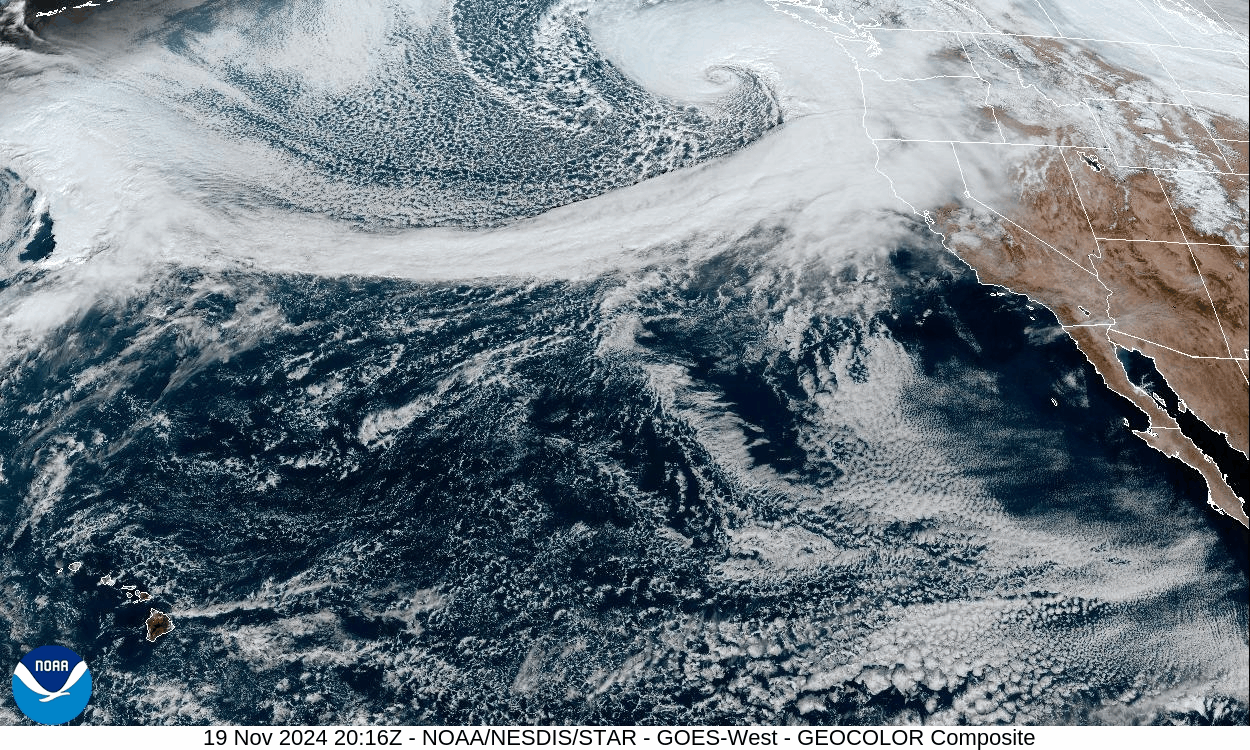
And a bomb cyclone is what we saw hurtling its way toward the west coast of North America, set to impact areas from California to British Columbia.
Now, associated with this whole system was an atmospheric river. This is also not a new term, it was coined in the 1990s as a way to describe a narrow band of water vapour transport. Describing it as a river is fitting because these types of systems can actually hold and precipitate as much water as major rivers on land.
They generally happen and we see the largest impacts on the west coasts of Europe and North America. In 2019, The Center for Western Weather and Water Extremes (CW3E) at the Scripps Institution of Oceanography released a five-level scale. With a Category 5 atmospheric river being the strongest.
A very common type of Atmospheric River is known as the “Pineapple Express” and this is when we see tropical moisture transported from Hawaii to the west coast of Canada or the United States. Get it?
This system brought dangerous conditions with it. With everything from flood warnings to winter storm warnings in effect.
Gusts up to 170km/h were recorded at a weather station just off the coast of Vancouver Island. Areas from British Columbia to California saw snowfall.
Hundreds of thousands were without power in Canada and the US. Also, at least two people have been killed.
And we are expecting another one right behind it. Then this first will likely make an appearance again as they dance around each other.
Super Typhoon Man-Yi Hits the Philippines
Last week in the weekly round-up post, we talked about how a train of storms had been impacting the Philippines with devastating consequences. Since the last week of October, we have seen the landfall of Typhoon Yingxing, Kong-Rey, Trami, Toraji and Usagi.
This last week we saw Super Typhoon Man-Yi make landfall. It was one of the strongest to hit and left at least eight killed and more injured.
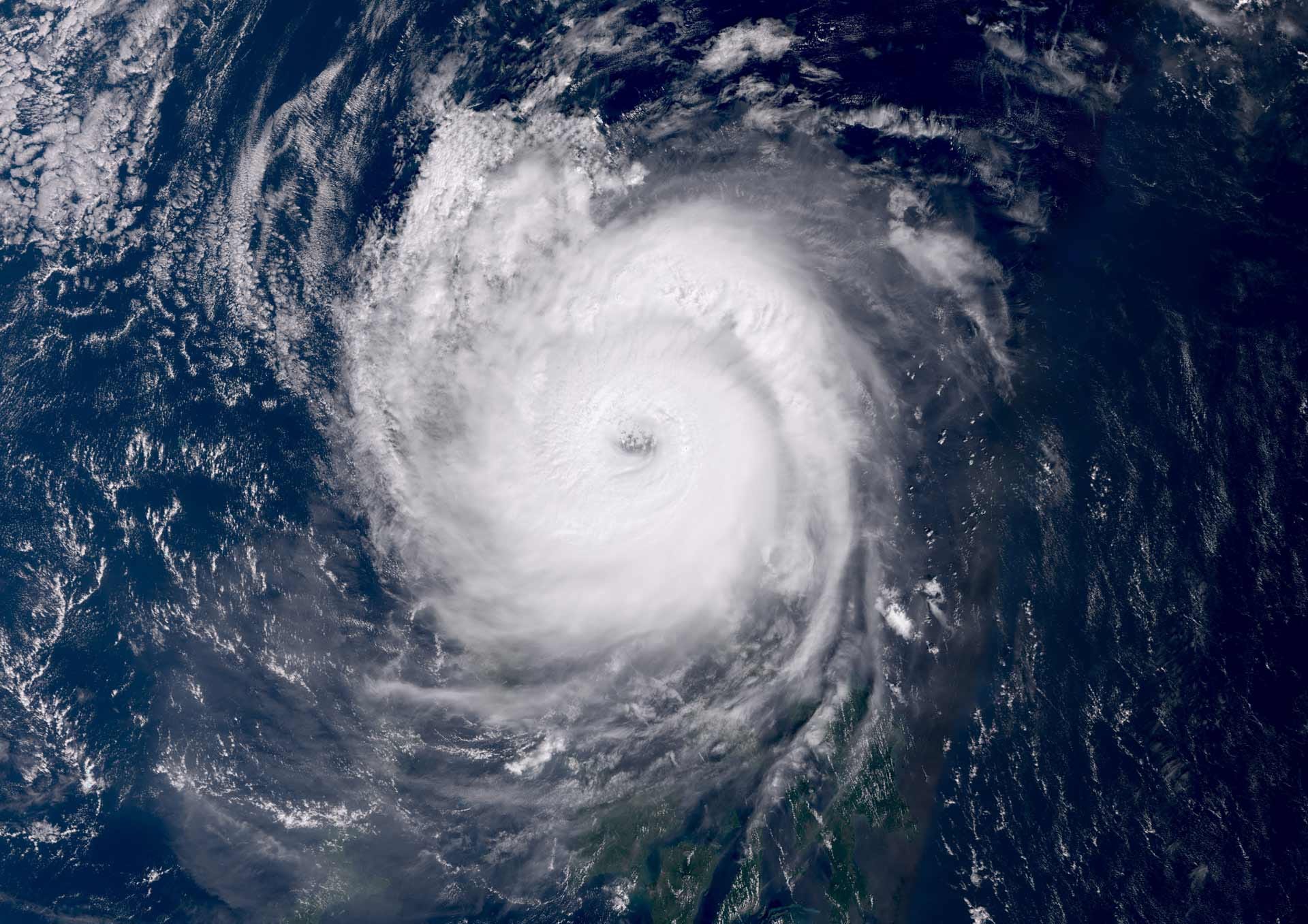
When Man-Yi made landfall, it did so with sustained winds of 195km/h in the island province of Catanduanes.
This storm adds to the crisis caused by these back-to-back storms, as it brought heavy rainfall, life-threatening flash flooding and landslides.
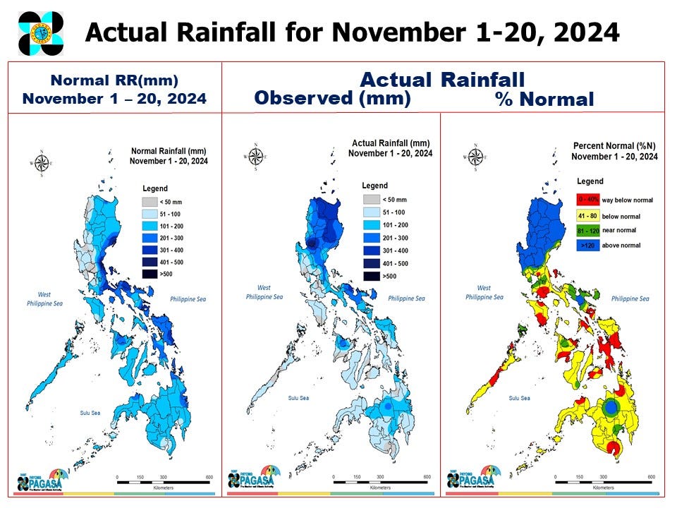
That’s right, six storms in a month. And four so far in November. This, according to the Japan Meteorological Agency, was the first time this has happened since their records began in 1951.
If we look at the first three weeks of November for rainfall across the Philippines, we see that areas of Luzon have seen over 500mm of precipitation, with basically the entire island seeing over 120% of normal rainfall.
Dust Storm in the Mediterranean
On November 14th, a dust storm spanning over 700km was seen on satellite imagery over the Mediterranean Sea.
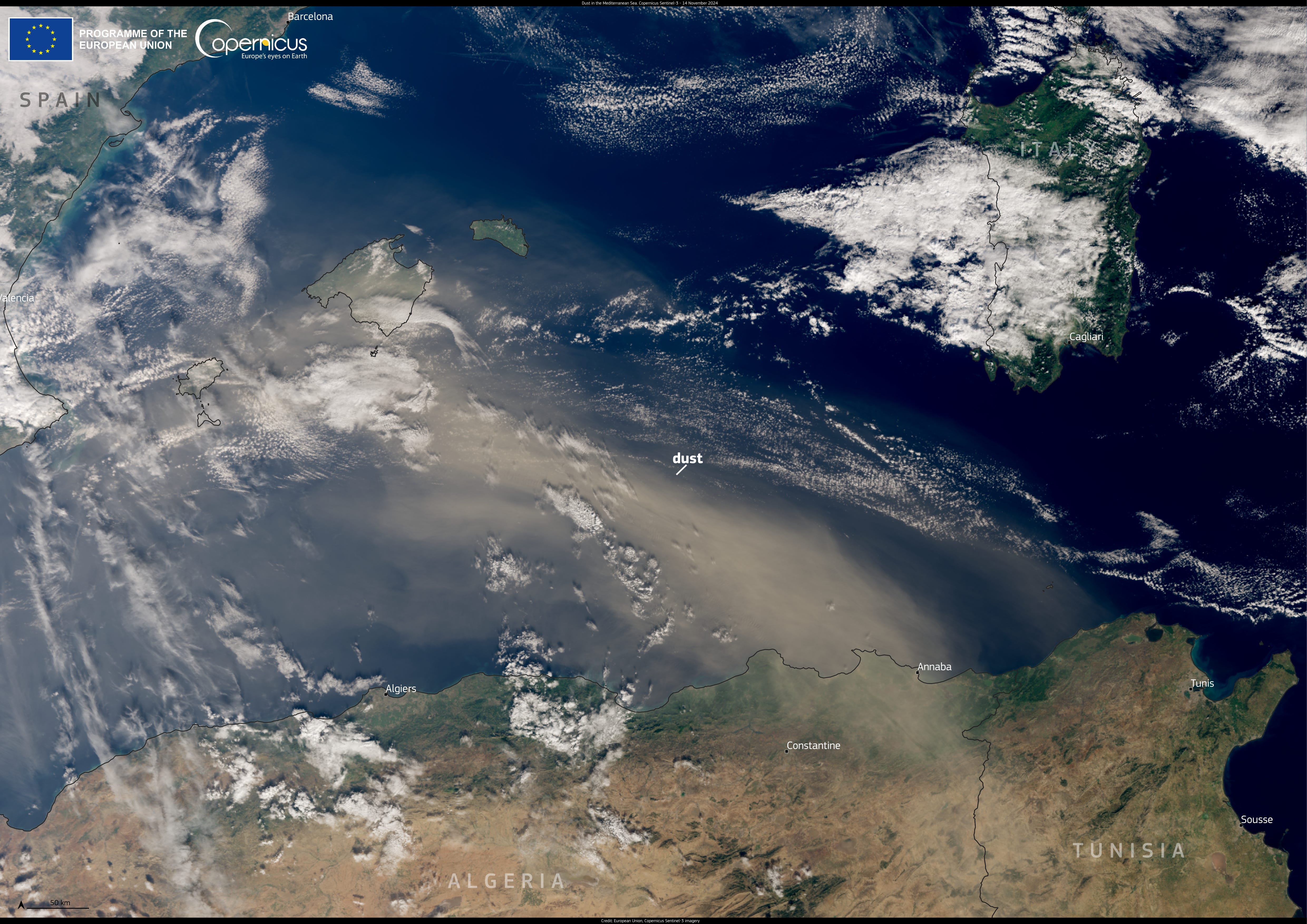
According to Copernicus, “In this image, the plume can be seen extending from Algeria northward over the Spanish Balearic Islands.”
This brought hazy conditions across the region.
Storm Bert Heads For The UK
The next named storm is headed straight for the UK and it is set to bring wind, rain and snow — Bert.
Warnings are already in place, and snowy conditions have already started across the country.

Unsettled conditions look likely to continue through to next week.
Record Breaking Temperatures
I don’t think that we can go through a week without records being broken when it comes to temperatures around the world.
Africa has seen some unseasonable heat recently. South Africa has been experiencing a heat wave from day to night. Stations recorded some of their hottest November nights on record in Grabouw, East London and Mossel Bay. While daytime temperatures have been breaking records by over 2-3°C. Meanwhile, across northern Africa, temperatures have felt more like summer in areas of Algeria and Lybia.
Across the Caribbean and Gulf of Mexico, temperature records have been broken from Honduras to Belize to Curacao.
And so many temperature records have been broken in Asia, that it would take an entire post to list them all.
More AMOC News
I wrote a post a few weeks ago, about the AMOC — you can read it here.
And this week, we have had a new study released once again, showing that many climate models have underestimated the impact of freshwater influx.
This study, published in Nature Geosciences wrote this:
We also show that accounting for upper-end meltwater input in historical simulations significantly improves the data–model agreement on past changes in the Atlantic Meridional Overturning Circulation, yielding a slowdown of 0.46 sverdrups per decade since 1950. Including estimates of subarctic meltwater input for the coming century suggests that this circulation could be 33% weaker than its anthropogenically unperturbed state under 2 °C of global warming, which could be reached over the coming decade. Such a weakening of the overturning circulation would substantially affect the climate and ecosystems.
What does this mean in plain words? Well, basically we have underestimated the slowdown due to freshwater influx.
There is a 90–100% probability that the AMOC will weaken even faster than previously expected. And this means that impacts could be sooner than later.